This covers the last day of our trip to Dunkeld and is almost completely devoted to the drive back to Mallacoota. We rose from our beds promptly and did a short stroll around the walled garden, packed the car and headed off. There was a small diversion to drop the photo album we had been lent back in the meter box at the Catholic Church.
We set off at pretty much exactly 0800 hours with Polly (we were using Google Maps rather than the Mazda system) suggesting we'd be home by 1710. The drive along the Glenelg Highway to Streatham was uneventful apart from getting foggy near Streatham. Once we turned North the only excitement was the number of wind turbines. As we approached those photographed on the way down we could see a lot more that had been out of sight heading South. Frances did a count and concluded that it was over 100 turbines in a number of farms.
As we approached Melbourne Polly asked if we wished to switch to a faster route as there was congestion ahead. Wedid so and headed off on the Ring Road. Here we got to see a lot of powerlines!
A little further and Polly advised that this route was also congested would we like another. Yes please. We found ourselves heading into the CBD, expecting to go along Victoria Street and down to Batman Avenue.
Possibly that had been the intention but then more congestion was identified and we got taken down some part of Latrobe Street and into William Street. I don't know how bad the congestion we avoided was, but gridlock describes where we went, especially the Burnley Tunnel. This is the approach.
I wasn't game to ask Frances to take a photo in the tunnel: three lanes full of trucks doing 10kph and 50l/100km! Eventually we got some clear air and swapped drivers at Gumbaya World. All good for the next 100 km or thereabouts when Polly suggested going through Moe rather than sticking to the M1. I assumed this was all to avoid Bogan Central (aka the roadworks between Sale and Traralgon).
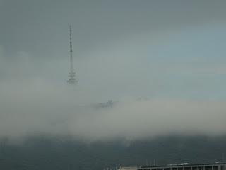
I will include a map showing what happened a little later in this post but here are some snips and snaps. this first is a snip from Google Earth of the Yallourn area. The road we were on is on the LHS of the images and heads off NE. Where it bends is the Yallourn Power Station.
This is the approach to the Station (which I have tried to photograph from the M1 many times with no success).
Its all a matter of getting close enough!
Getting the generated power to where it has been sold.
This is the Latrobe River, which I suspect has something to do with the steam coming out of the cooling towers!
Somewhere along here we drove through an area where every bit of infrastructure (eg the school) was imaginatively called Brown Coalmine. I can't find this in Google maps, but there is a Brown Coalmine Rd leading in to Tyers.
Further research suggests the village has been renamed Yallourn North.
At about this point my iphone spat the dummy as it was overheating. (I think that this was due to having the Qi charger in the car going as well as having the phone connected via a USB cable. I shall check this with Apple when next in Canberra.) What ever the cause, no more Polly and over to Sheila, the Australian (? she has real trouble with some place names) version on Mazda. We got a good look at, but a crummy photo of) a coal mine showing the yellow overburden with the evil black stuff under it.
Looking across the Valley shows another industrial complex which I suspect is the Loy Yang power station.
That is shown in the next two snips from Google Earth.
I think my image was taken from somewhere near Glengarry West.
We now get to where Sheila went loopy. Polly (phone app) took us as far as Yallourn. Sheila took us along the route marked with magenta arrows: she has a preference for going through the town of Sale with about 10 sets of traffic lights. We didn't realise what she was up to until we got through the crucial roundabout at Fulham, where we should have followed Polly's inner route (green arrows) to dodge the town. What we should have done was followed the blue arrows at Winnindoo and joined Polly's outer route, thus also avoiding the bogan duplication roadworks which took us down to 40kph for about 5km from Nambrok.

It was also interesting how our anticipated time of arrival varied. Following the fiasco of the Burnley Tunnel reroute by Polly the time had blown out to about 1735 (ie that cost us some 25 minutes - probably the exact amount the diversions claimed to be saving us). That was still the situation when the iphone overheated: then Sheila was fired up and she was showing 1825! That was still the case after we refueled in Bairnsdale, but somewhere around Orbost it started dropping and by Cann River (70kms to go) it was showing 1750, which is when we arrived. So, allowing 5 minutes to refuel, the stops to sort out the satnavs and the traffic 'system' in Sale cost us about another 15 minutes.
Whatever, we got home at 1750, unloaded the car and had a glass of red!


Comments
Post a Comment