Posts

Showing posts with the label weather

The Prom

Image
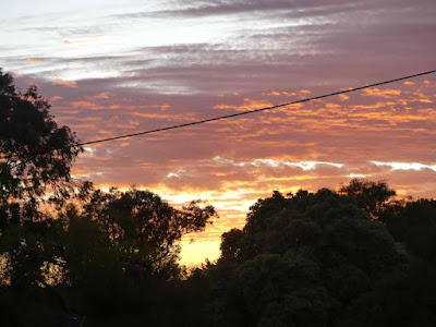
 One of our reasons for choosing this area was to visit Wilson's Promontory, mainland Australia's most Southerly spot.  (It is also one of the windiest with a record just of 170 kph in August 1991.)   Before heading off there was a very pleasant sunrise.  This was a great improvement in the weather as most days on this trip the early mornings have been 8/8ths cloud. En route we got good views of a couple of the turbines from the Toora wind farm (we came along the highway this time)  ... ... and some weird chainsaw art beside the road. It was 87 km to the Park entrance and a further 20 to the campground at Tidal River, and then - had we been bold enough to try - 24km to the tip (5 hours walking).  The drive was satisfactory with only one bit of weirdness as the GPS took us round the farms (rather than the houses) to avoid Foster: I guess there might be a traffic jam there in Summer.   The gate to the National Park was curious: I presume it is ...

Tarra Bulga etc

Image
 The major National Park near Yarram is Tarra-Bulga in the Strzlecki Ranges.  Polly, the phone version of Google Maps GPS system, initially sent us on an interesting route as she decides to avoid small country towns.  In this case Yarram, a transit of which really is not going to add any time.  However, she says "turn left" so I do.  The road is rather narrow and well endowed with vegetation. This was our first encounter with the Tarra River.  It seemed rather trivial so I looked up recent rainfall for Yarram and there has only been 36mm so far this year.  No wonder the ground has been cracked in a few spots. At Tarra Falls a pretty caterpillar was exploring a fern trunk. Here is the top of the fals Lower down: the official steps only go about 1/4 of the way and I was discouraged from following an unofficial goat track. We had a GPS "moment" when we got close to the Park Visitor Centre.  There were 2 roads off to the right and I took the first....